![](/images/other/stat-length.png)
![Trail Walking La Roche-Guyon - La Roche Guyon - Les falaises - Photo](https://media.geolcdn.com/t/1900/400/ext.pjpeg?maxdim=2&url=https%3A%2F%2Fstatic1.geolcdn.com%2Fsiteimages%2Fupload%2Ffiles%2F1553511878bg_sport_marche.png)
La Roche Guyon - Les falaises
marcel.F
User
![Length](/images/other/stat-length.png)
Length
7.7 km
![Max alt](https://static1.geolcdn.com/siteimages/upload/files/1508320355ic_sort_altitude_max_24dp.png)
Max alt
149 m
![Uphill gradient](https://static1.geolcdn.com/siteimages/upload/files/1508320355ic_sort_den_pos_24dp.png)
Uphill gradient
132 m
![Km-Effort](/images/other/stat-length.png)
Km-Effort
9.5 km
![Min alt](https://static1.geolcdn.com/siteimages/upload/files/1508320355ic_sort_altitude_min_24dp.png)
Min alt
74 m
![Downhill gradient](https://static1.geolcdn.com/siteimages/upload/files/1508320355ic_sort_den_neg_24dp.png)
Downhill gradient
134 m
![Boucle](https://static1.geolcdn.com/siteimages/upload/files/16400158638029165_repeat_loop_refresh_sync_direction_icon.png)
Boucle
Yes
Creation date :
2014-12-10 00:00:00.0
Updated on :
2014-12-10 00:00:00.0
![Walking](https://static1.geolcdn.com/sitytour/trail-icons/101.png)
2h09
Difficulty : Medium
![Scan this QR Code to open this trail in the SityTrail application](https://capi.geolives.com/qq0zvz2zws4bq2lad0pu/sitytour/trails/184545/qr.png?size=200)
FREE GPS app for hiking
About
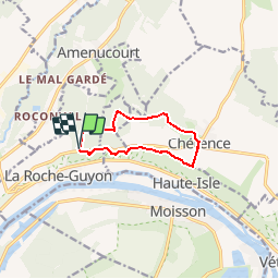
Trail Walking of 7.7 km to be discovered at Ile-de-France, Val-d'Oise, La Roche-Guyon. This trail is proposed by marcel.F.
Description
Départ parking de la forêt régionale de la Roche Guyon (vers arboretum sur D100)
boucle après midi après pique-nique vers Chérence et retour falaises
Positioning
Country:
France
Region :
Ile-de-France
Department/Province :
Val-d'Oise
Municipality :
La Roche-Guyon
Location:
Unknown
Start:(Dec)
Start:(UTM)
400503 ; 5437996 (31U) N.
Comments
Trails nearby
![On foot On foot](https://static1.geolcdn.com/sitytour/trail-icons/100.png)
Vétheuil Bords de Seine et coteaux
On foot
Easy
(1)
Vétheuil,
Ile-de-France,
Val-d'Oise,
France
![](/images/other/stat-length.png)
9.5 km | 11.8 km-effort
2h 38min
![](https://static1.geolcdn.com/siteimages/upload/files/16400158638029165_repeat_loop_refresh_sync_direction_icon.png)
Yes
![Trail Walking La Roche-Guyon - La Roche Guyon - Chérence - Photo](https://media.geolcdn.com/t/375/260/ext.jpg?maxdim=2&url=https%3A%2F%2Fstatic1.geolcdn.com%2Fsiteimages%2Fupload%2Ffiles%2F1553511878bg_sport_marche.png)
![Walking Walking](https://static1.geolcdn.com/sitytour/trail-icons/101.png)
La Roche Guyon - Chérence
Walking
Medium
(2)
La Roche-Guyon,
Ile-de-France,
Val-d'Oise,
France
![](/images/other/stat-length.png)
8.8 km | 11.5 km-effort
2h 30min
![](https://static1.geolcdn.com/siteimages/upload/files/16400158638029165_repeat_loop_refresh_sync_direction_icon.png)
Yes
![Trail Walking Vétheuil - La Roche Guyon depuis Vétheuil - Photo](https://media.geolcdn.com/t/375/260/ext.jpg?maxdim=2&url=https%3A%2F%2Fstatic1.geolcdn.com%2Fsiteimages%2Fupload%2Ffiles%2F1553511878bg_sport_marche.png)
![Walking Walking](https://static1.geolcdn.com/sitytour/trail-icons/101.png)
La Roche Guyon depuis Vétheuil
Walking
Medium
(1)
Vétheuil,
Ile-de-France,
Val-d'Oise,
France
![](/images/other/stat-length.png)
20 km | 27 km-effort
6h 0min
![](https://static1.geolcdn.com/siteimages/upload/files/16400158638029165_repeat_loop_refresh_sync_direction_icon.png)
Yes
![Trail Walking La Roche-Guyon - La Roche-Guyon boucle - Photo](https://media.geolcdn.com/t/375/260/ext.jpg?maxdim=2&url=https%3A%2F%2Fstatic1.geolcdn.com%2Fsiteimages%2Fupload%2Ffiles%2F1553511878bg_sport_marche.png)
![Walking Walking](https://static1.geolcdn.com/sitytour/trail-icons/101.png)
La Roche-Guyon boucle
Walking
Easy
(1)
La Roche-Guyon,
Ile-de-France,
Val-d'Oise,
France
![](/images/other/stat-length.png)
15.5 km | 19.5 km-effort
4h 15min
![](https://static1.geolcdn.com/siteimages/upload/files/16400158638029165_repeat_loop_refresh_sync_direction_icon.png)
Yes
![Trail Walking Vétheuil - Vetheuil - la petite suisse - Photo](https://media.geolcdn.com/t/375/260/ext.jpg?maxdim=2&url=https%3A%2F%2Fstatic1.geolcdn.com%2Fsiteimages%2Fupload%2Ffiles%2F1553511878bg_sport_marche.png)
![Walking Walking](https://static1.geolcdn.com/sitytour/trail-icons/101.png)
Vetheuil - la petite suisse
Walking
Easy
(1)
Vétheuil,
Ile-de-France,
Val-d'Oise,
France
![](/images/other/stat-length.png)
15.5 km | 20 km-effort
4h 20min
![](https://static1.geolcdn.com/siteimages/upload/files/16400158638029165_repeat_loop_refresh_sync_direction_icon.png)
Yes
![Trail Walking La Roche-Guyon - La Roche Guyon - Forêt + falaises - Photo](https://media.geolcdn.com/t/375/260/ext.jpg?maxdim=2&url=https%3A%2F%2Fstatic1.geolcdn.com%2Fsiteimages%2Fupload%2Ffiles%2F1553511878bg_sport_marche.png)
![Walking Walking](https://static1.geolcdn.com/sitytour/trail-icons/101.png)
La Roche Guyon - Forêt + falaises
Walking
Medium
(2)
La Roche-Guyon,
Ile-de-France,
Val-d'Oise,
France
![](/images/other/stat-length.png)
12.1 km | 15.3 km-effort
3h 22min
![](https://static1.geolcdn.com/siteimages/upload/files/16400158638029165_repeat_loop_refresh_sync_direction_icon.png)
Yes
![Trail On foot Gommecourt - Accès gr2 - Photo](https://media.geolcdn.com/t/375/260/cbcaffe3-547b-4d39-aa4c-1153b2cb86dd.jpeg&format=jpg&maxdim=2)
![On foot On foot](https://static1.geolcdn.com/sitytour/trail-icons/100.png)
Accès gr2
On foot
Easy
Gommecourt,
Ile-de-France,
Yvelines,
France
![](/images/other/stat-length.png)
5.6 km | 6.7 km-effort
1h 31min
![](https://static1.geolcdn.com/siteimages/upload/files/16400158638029165_repeat_loop_refresh_sync_direction_icon.png)
No
![Trail Walking Haute-Isle - cherence vetheuil - Photo](https://media.geolcdn.com/t/375/260/30489cd7-a8cf-4c9a-96b0-b376801dc544.jpg&format=jpg&maxdim=2)
![Walking Walking](https://static1.geolcdn.com/sitytour/trail-icons/101.png)
cherence vetheuil
Walking
Haute-Isle,
Ile-de-France,
Val-d'Oise,
France
![](/images/other/stat-length.png)
11.1 km | 14.5 km-effort
3h 21min
![](https://static1.geolcdn.com/siteimages/upload/files/16400158638029165_repeat_loop_refresh_sync_direction_icon.png)
Yes
![Trail Walking La Roche-Guyon - La Roche Guyon - Photo](https://media.geolcdn.com/t/375/260/435b2e08-c75f-415f-8c45-43907ed8c4dd.jpg&format=jpg&maxdim=2)
![Walking Walking](https://static1.geolcdn.com/sitytour/trail-icons/101.png)
La Roche Guyon
Walking
Very easy
La Roche-Guyon,
Ile-de-France,
Val-d'Oise,
France
![](/images/other/stat-length.png)
8.6 km | 11.4 km-effort
2h 53min
![](https://static1.geolcdn.com/siteimages/upload/files/16400158638029165_repeat_loop_refresh_sync_direction_icon.png)
Yes